How Geofences Can Create Better Transportation Projects

Once construction begins on a large transportation project, it is not uncommon for project managers and owners to hear a lot of feedback – often negative – from the public who have to live with that construction on a daily basis. For many, the first sign of orange barricades and hardhats on the road is the first time they realize the project is happening.
But many transportation projects are planned for years before the first shovel digs into the ground. So why doesn’t public feedback ramp up until bulldozers show up?
It’s hard to get public involvement in the planning and study stages of a big project. I have been in several public meetings in the earliest stages of these projects where just a handful of citizens show up to learn more or voice their opinions. On the other hand, I have sat in public meetings with hundreds of people who learn of a project as construction begins – and many of them aren’t happy about it.
Because it is so hard to change a project in the construction phase, it is imperative to get as much public feedback as early as possible. This feedback can really help shape a project into a vision that works for every stakeholder.
Putting an ad in the legal section of local newspapers isn’t as effective as it once was. In order to get valuable public input, we must find better ways to get in front of the public.
One such way is geofencing.
What is Geofencing?
Geofencing uses GPS or RFID technology to create a virtual geographic boundary, enabling software to trigger a response when a mobile device enters or leaves a particular area.
The transportation industry is already finding uses for geofencing technology. For instance, several major airports use geofences around their properties to impose fees on Uber, Lyft and other transportation network companies (TNCs). This technology helps airports offset parking revenue that has been declining as more and more travelers take TNCs to and from airports.
Geofencing can also be used for hyper-targeted marketing initiatives, known as geotargeting. You may remember the craze around Pokémon Go that sent hundreds of thousands of players on their phones to a wealth of destinations looking for elusive Pokémon characters.
Many retailers and consumer goods companies used mobile geotargeting to propel their brands to a new level of engagement. Retailers tagged the IDs of smartphone users within a five-mile radius of their locations and placed Pokémon Go “like” ads in mobile apps driving traffic to their locations.
Geofencing Gets Good Feedback
At RS&H, we oversee planning studies on transportation corridors that may span for dozens – or even hundreds – of miles. Getting feedback during the planning stage of even these large projects can be difficult, but geofencing and geotargeting are proving to be much more effective than traditional public outreach.
Using a geofence over the corridor, we can reach motorists who are passing through and push digital communications to them. These may come in the form of digital surveys or project information or even 3D flythrough models powered by programs like Bentley’s ConceptStation. We can direct them to a project’s Facebook page or website and other areas where they can submit meaningful input.
The results of geofencing and geotargeting could be seen right away. Recently, one of our project Facebook pages had about 100 people following it before we launched our geofence around the project corridor. A month later, the page had several thousand followers.
The Bottom Line
Geofencing and geotargeting may be just the tools your next transportation project needs to consider during the planning stages. More feedback from those who use the transportation corridor will help inform and create a better project for everyone.
Related Insights
Almaghrabi will lead the strategic development and implementation of advanced digital solutions across the firm’s transportation projects.

RS&H transportation leaders Tom Everett, PE, and Jim Hullett unpack the current state of the transportation industry—and what comes next.
The transportation sector is at a pivotal moment. As infrastructure projects grow in complexity and scale, traditional paper-based workflows are proving insufficient.
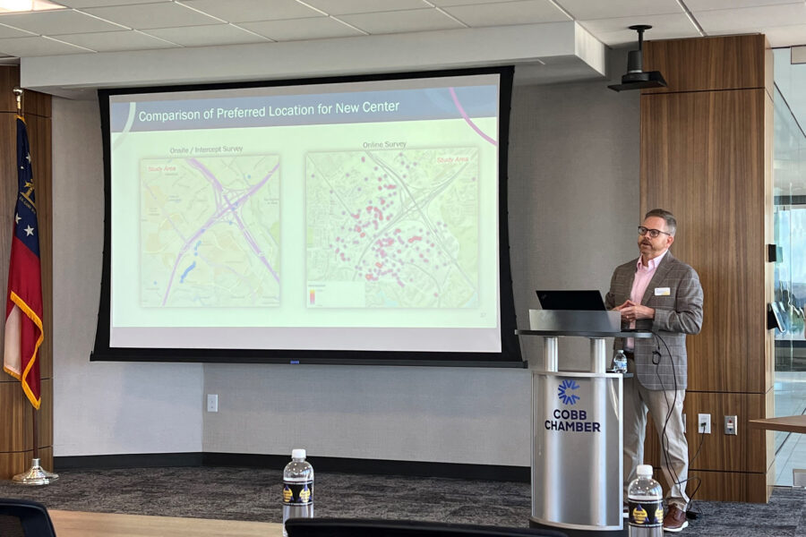
RS&H has been named a 2026 American Council of Engineering Companies (ACEC) Georgia Engineering Excellence Merit Award, recognizing the firm's exceptional work on the Cumberland Transit Center Site Feasibility Study for the Cobb County Department of Transportation (DOT).