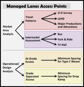
The Managed Lane Access Tool utilizes database and spreadsheet programs to efficiently and effectively identify solutions for determining market need, feasibility, and optimal lane access locations. Specifically, the tool can identify major home-to-work trip origin-destination pairs, and provide connections to multimodal facilities. The tool combines traffic operation (level-of-service) and highway design components (weaving sections, ramp spacing) with the market area analysis (home/work characteristics) and a multimodal assessment to determine managed lane access locations.
To assess travel patterns for commuters, the tool uses the Longitudinal Employer-Household Dynamics (LEHD) data and identifies home-to-work relationships within the project corridor using a custom geographic information system (GIS)-based script. These relationships are used to determine the potential travel demand between each interchange, producing an Origin-Destination (O-D) matrix or trip table. The O-D matrix identifies interchange pairs with the greatest number of potential home-based work trips. The tool then displays the resulting O-D pairs to determine access locations with the highest travel demand opportunities. Other O-D data sets beyond the LEHD can be used in developing travel pairings, including traffic forecasting trip tables or specific trip tables for major destinations, such as airports, theme parks, or downtowns.
The tool can analyze multimodal facilities when determining access points, such as airports, park and ride lots, rail stations, and transit hubs. In addition, planning managed lane access from a park and ride lot or transit hub maximizes availability and promotes the use of transit and ride sharing, which relieves congestion, as well.
Freeway weaving requirements also can identify operationally feasible access point locations. The tool analyzes the geometry of the corridor to determine where access is feasible and safe. By assessing weaving maneuvers from at-grade ramps, minimum spacing for each potential access point is determined and graded based on user defined lane changing standards. For example, several lane changing distances can be applied, such as 500, 800, or 1000 feet per lane change. Additionally, the tool provides the opportunity to assess grade-separated and direct access ramps at interchanges versus between existing at-grade interchanges.
The Managed Lane Access Tool is yet another advancement to identify potential access locations that maximize the potential users of the managed lanes, compliment the multimodal transportation network, and have minimal impact to the existing highway structures and interchanges. The tool can be applied to retrofit existing high-occupancy vehicle lanes or others, as well as new capacity and managed lanes projects.
When applied in the planning and pre-design phases, the tool allows for the assessment of multiple criteria and therefore provides a screening function for potentially all ramp options to identify the highest congestion relief opportunities. It also helps organizations understand the potential geometric limitations and/or ramp configurations necessary to accommodate particular ramp locations.
The cost savings related to the analysis, subsequent/design schedule, and ultimately understanding the congestion relief achieved versus construction costs are major outcomes of the application of this tool.