HUC Boundaries and the Watershed Approach: The Wrong Tool for the Job

As scientists, we’re always on the lookout for universal theories, model applicability, and patterns in nature. Regulators are called upon to develop methodologies that are rapid, repeatable, and accessible. Permittees are looking for consistency in regulatory requirements so we can assess project feasibility.
All of these are understandable and worthy goals, but oftentimes their fulfillment by initiating a “one-size-fits-all” approach can cause some serious unintended consequences.
One such case is the use of Hydrologic Unit Code (HUC) boundaries as true watershed boundaries. From New Brunswick, Canada, to Brownsville, Texas, this is inappropriate for systems in the coastal plain. It can also present regulatory problems for watersheds in montane regions, like the Sierra Nevadas or the Rockies.
What is a HUC Boundary?
Developed by the U.S. Geological Survey, the HUC system was to serve as a “mailing address” for a given water body in an effort to break the nation’s waters into different hierarchical scales of potential influence, thereby providing a framework upon which to build discussions relating to the nation’s water supply.
Why should you care about HUC Boundaries?
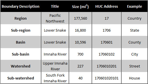
HUC boundaries are often used in Clean Water Act compliance. If you impact a wetland or stream in an area using this practice, then you would have to mitigate or replace that wetland or stream within the same HUC (i.e. water resources are fungible within the HUC).
But from an ecological perspective, HUCs can be quite large with little ecological parity between sites.
A HUC can also be a relatively small area. Some have experienced significant development, so locating adequate mitigation within those areas can be difficult and extremely expensive.
From a conservation perspective, if your goal is no net loss, you might be failing if you assume all resources within a HUC are fungible.
In many cases, HUCs are being used as true watershed boundaries. But, our research has shown this should not be the case.
Why shouldn’t HUCs be used as true Watersheds?
This framework is rather straightforward, and on the surface, may seem logical to use. But, there are some critical flaws to using this heuristic as a water management tool.
The principal flaw: water from one HUC cannot enter into an adjacent HUC at the same hierarchical level for them to be considered unique watersheds, but in many situations, they do.
When “watersheds” were decided to be too large to be useful, they were arbitrarily split somewhere in the middle. When thought to be too small, they were lumped together, regardless of actual hydrology. The authors of the HUC system point out that it does not account for:
- Groundwater interactions
- High flood conditions
- Man-made diversions
- Impoundments
- Deltaic systems
- Very small or very large areas between topographic breaks
The watershed approach is supposed to consider landscape scale, land use, historic and potential aquatic resource conditions, past and projected aquatic resource impacts, and terrestrial connections between aquatic resources in addition to ecological function. This cannot be done when all of these points are ignored.
Our Research
Our research conducted found that many HUCs are not true watersheds, and therefore, the HUC system should not be used for the “watershed approach.”
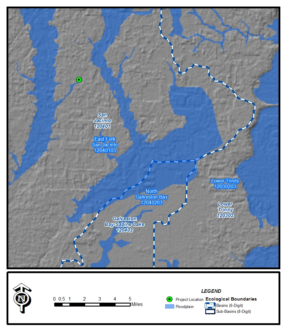
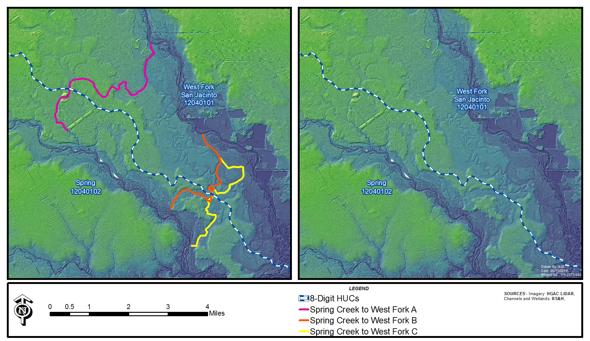
Using LiDAR driven topographic maps to derive longitudinal profiles across the landscape, FEMA flood data, and extensive field work and ground-truthing, we found that water routinely flowed between not only 8-digit HUCs, but between 6-digit HUCs too. Our research found that:
- 100-year floodplain boundaries cross over multiple HUC boundaries (both 8-digit and 6-digit).
- Streams and other natural water courses often cross over multiple HUC boundaries, which are supposed to be the areas of highest elevation (so water runs uphill).
- The “ridge” dividing HUCs in some cases is literally inches high and consist of a mosaic of wetland habitats.
- Ridges separating HUCs were shown to be inches high in areas that habitually flood +10 feet each year.
- Over half of HUCs are not true watersheds because they exist in the middle of a river system. This means they have catchment flowing into them, therefore they don’t meet the definition of a watershed.
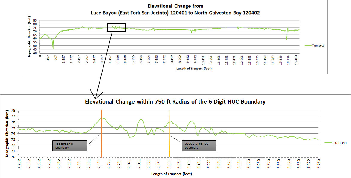
Looking at topographic maps across the U.S., this is an issue for all watersheds in the coastal plain of North America. If water is not supposed to be able to cross from one HUC to the next, it appears to be doing it quite often.
Future Plans
Going forward, regulators, permittees, and stakeholders need to work closely together to implement a watershed approach that truly is a watershed approach to achieve the goal of no net loss, and hopefully over time, a net gain in aquatic resources.
By supporting funding to the agencies responsible for developing the tools of assessment and providing our own collected data to supplement their efforts, together we can achieve regional assessment models to protect our waters and the biota that depend on them for generations to come.
Related Insights
Listen to RS&H’s Jennifer Youssef, Jessica Whitlock, and Victoria Villareal as they have a discussion with AdventHealth’s Michael Compton – Acute Care Studio Leader, and Stephen Szutenbach – Project Manager about EBD.

In this episode of AEC Perspectives RS&H Vice President, Richard Stump, joins host Bryan Nicol for an insightful conversation about working in the federal sphere.
To commemorate Women's History Month, RS&H sat down with Senior Vice President and East Regional Leader for Infrastructure Janie Tiedeman, PE. Tiedeman is not only the chair for RS&H’s inaugural DE&I Steering Committee, but also serves as chair for RS&H’s women’s professional network, Ignite.

While each project is unique, and many factors influence design, we’ve identified six factors to consider when adding or upgrading a facility. We’ll take a deeper look at each factor, including what it means to design, how to incorporate the idea, and examples from our previous projects.